
We had a perfect May long weekend hiking in Prince Albert National Park, exploring four beautiful and unique trails: the Waskesiu River, Boundary Bog, Mud Creek, and Shady Lake. Each one offered something different—from peaceful boardwalks to winding forest paths, bird calls to bubbling creeks.
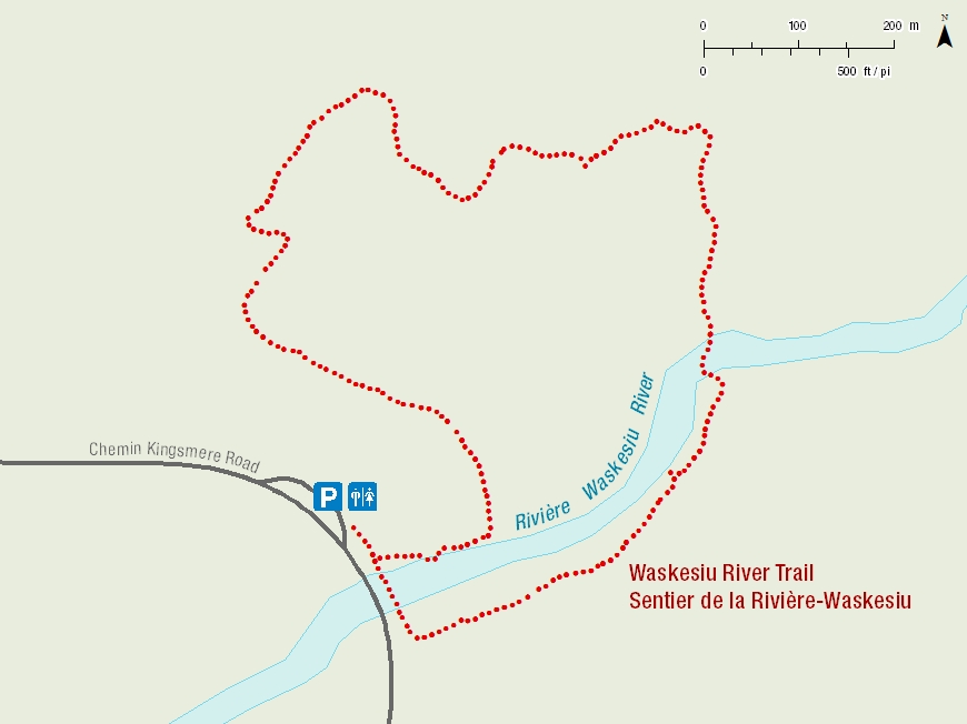
We started with the Waskesiu River hike on Friday morning, it is one of the most popular and accessible trails in Prince Albert National Park. This 2.5 km forest trail winds through black spruce and aspen parkland and begins with a 200-metre boardwalk that follows the river’s edge, where you’ll often spot geese, ducks, and the occasional curious squirrel.
Most people follow the loop in the same direction, starting with the boardwalk through a black spruce forest along the river. Some turn back at the end of the boardwalk, never discovering that trail turns into an open aspen woodland just beyond the river.
Lenght/Time: 2 .5 Km / 45 to 60 minutes
Level of Difficulty: Moderate
Trailhead: 6 km from the visitor center on the Kingsmere Road.
GPS Co-ordinates for Trailhead (in decimal degrees):
Lat.: 53.96409183 Long.: -106.07224182
Map of the Waskesiu River Trail from the Prince Albert National Park homepage.
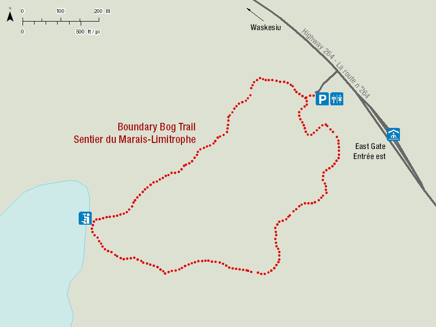
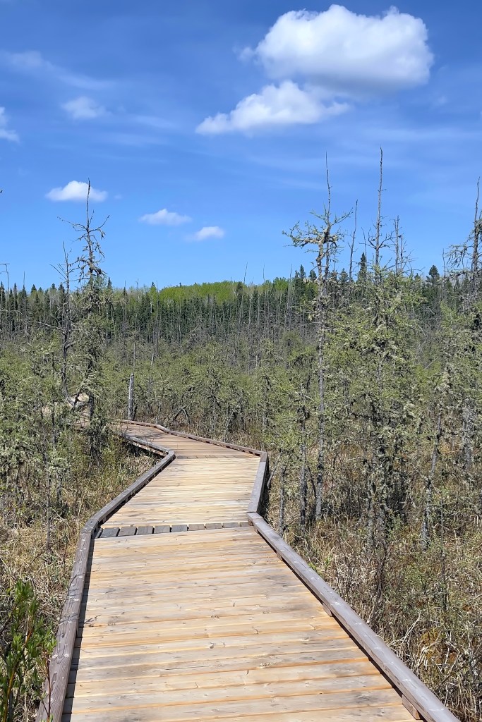
Later that same day, we explored Boundary Bog, a trail that leads you through a quiet, almost otherworldly landscape of black spruce and muskeg. The path begins in the aspen parkland and gradually descends into the bog, where a newly updated boardwalk carries you over a tamarack fen to the edge of a small lake.
Even when things get damp, the boardwalk makes this trail accessible, and the transition from forest to bog feels like walking into a different world. It was still early in the season, so we didn’t spot any pitcher plants (Sarracenia purpurea), but they’ll emerge later in the summer. They’re always fascinating to see!
Length/Time: 2 Km / 45 to 60 minutes
Level of Difficulty: Easy
Trailhead: 4.5 km from the Visitor Centre on Highway #264 just after east gate.
GPS Co-ordinates for Trailhead (in decimal degrees):
Lat.: 53.90951153 Long.: -106.02113941
Map of Boundary Bog Trail from the Prince Albert National Park homepage.

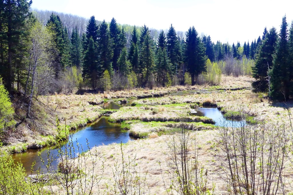
On Saturday, we hiked Mud Creek, a peaceful wander along the edge of Waskesiu Lake. The water was low during our visit, so we didn’t hear the usual sound of running water—but the rustling leaves and quiet forest made it just as easy to slow down and take everything in.
We’ve seen bears along this trail in the past—usually across the creek on the far bank—but not this time. A bear advisory had been posted, so we knew one had been spotted in the area recently. Still, no sightings for us on this trip—just a peaceful path shared with birdsong and the occasional squirrel.
Walking this trail feels like moving through layers of natural history—a transition zone from lake to river, and from spruce to aspen forest. As we moved along the trail, we caught glimpses of King Island on Waskesiu Lake and Mud Creek winding below.

Level of Difficulty: Easy
Lenght/Time: 2 Km / 45 to 60 minutes
Trailhead: 4.5 km down the Narrows Road, access at South Bay Day-use area.
GPS Co-ordinates for Trailhead (in decimal degrees):
Lat.: 53.89969156 Long.: -106.15693873
Map of Mud Creek Trail from the Prince Albert National Park homepage.
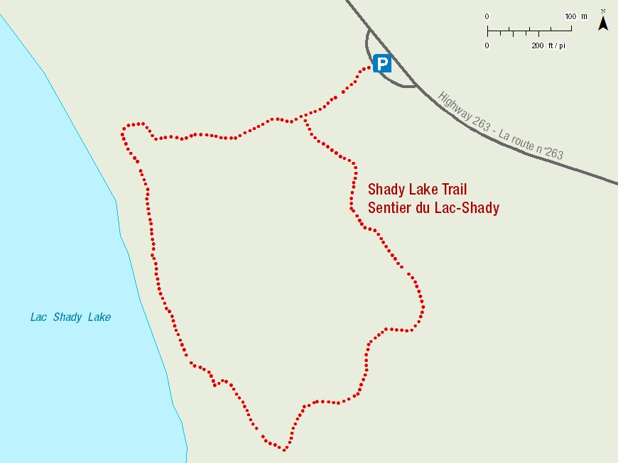
We wrapped up our weekend with the Shady Lake Trail, a quiet path that winds through mixed forest and travels along the shore of the pretty little Shady Lake. When we arrived at the parking lot, we were the only ones there, a promising sign for the peaceful walk we were hoping for.
The trail begins with a gentle switchback that leads you down through aspen trees to the lake’s shore. This loop trail offers beautiful views of the water tucked between the trees. It was the perfect place to end our hikes: cool shade, birdsong, and not another soul in sight. Just us, the breeze in the trees, and the stillness of the lake.
Length/Time: 1.7 Km / 40 minutes
Level of Difficulty: Moderate, Steep hills.
Trailhead: 8km from the visitor centre on highway #263
GPS Co-ordinates for Trailhead (in decimal degrees):
Lat.: 53.87131155 Long.: -106.10459901
Map of Shady Lake Trail from the Prince Albert National Park homepage.
Each of these trails reminded us how lucky we are to have a park like this so close to home. Prince Albert National Park is truly a treasure. This park has a way of slowing you down and filling you up, every trail offers something a little different. We can’t wait to return and explore even more of its beauty.


Leave a comment